The Buccaneer gas and oil field “rigs to reefs” 1977–2004
Abstract
From the Introduction: “Our objectives have been to conduct highresolution side-scan sonar surveys of debris field associated with two sites where obsolete oil and gas platforms installed in the mid-1960s have been topped and left in place as artificial reefs. These surveys are being supplemented with ROV and hydroacoustic surveys to determine fish and megafaunal abundance associated with the debris field."
From the Results and Conclusions: "Side-Scan Sonar Surveys. We obtained 100% side-scan coverage of the two sites in October
2003. Two debris fields are present at each site, one at the location of the 12-pile structure, and one at the location of the four-pile structure. Riprapp material covered a partially-buried segment of old pipeline at a location about 20- to 55-m east of the main debris pile at the GA296 site.
At GA288, bottom depth was on the order of 23 m, and the highest point of the debris field was on the order of 18-m deep. Maximum relief was thus about 5 m. Slightly greater relief was observed at GA296 (6 m) where the bottom depth was 22 m and the highest point of the debris field was about 16-m deep. At the GA288 site, the main debris field was mostly encompassed within a circle having a radius of 100 m whereas the four-pile structure debris field was largely contained within a circle having a radius of 50 m. Similarly, the main debris pile at GA296 site was contained within a radius of about 83 m, and the debris field at the old quarters platform at this site was within a radius of 55 m. Thus, the sites are similar in terms of size and relief.
Hydroacoustic Surveys
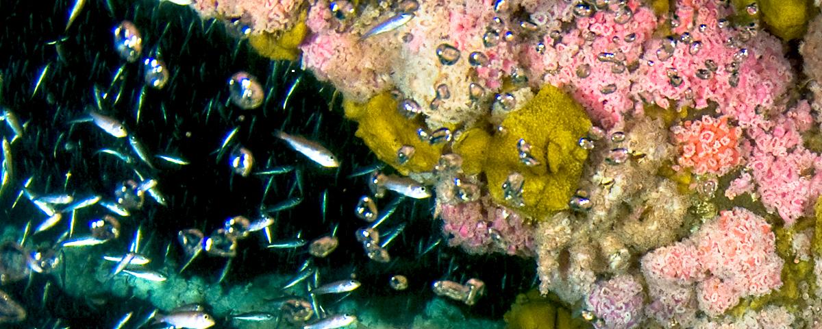
The hydroacoustic surveys showed that the debris fields comprised “islands” of relief extending above a relatively flat plain. “Clouds” of fishes hovered within and above the debris fields. The surrounding flat bottoms were virtually devoid of fish. Fish were abundant immediately above
the reefs, and abundance declined rapidly within a 100-m distance away from the reefs. Fish targets were present throughout most of the water column. The population estimates at GA288 and GA296 in October 2003 were 8,292 fish (95% CI = 5,655 to 10,928) and 7,558 (95% CI =
5,461 to 9,654) respectively. In August 2004, 4,837 (95% CI = 2,799 to 6,874) fish were estimated to have been present at GA288, and 7,352 (95% CI = 5,596 to 9,109) were estimated to have been present at GA296.
ROV and Diver Surveys
We did not obtain ROV surveys at the study area reef sites in October 2003, but the small debris pile at the GA288 site was surveyed by TPWD divers in September 2003 shortly after the structures had been reefed. Five TPWD divers performed roving surveys at site GA-288. They initially dove to the bottom and worked their way to the surface recording the relative abundance of fishes observed. The abundance categories ranged from sightings of single fish of a species to an observation of groups of a species numbering from a few (2–10 fish), to many (11–100 fish) to abundant (>100 fish of a species). “Abundant” fishes included only the tomtate Haemulon aurolineatum whereas species represented in the “many” category included the sheepshead
Archosargus probatocephalus, Atlantic spadefish Chaetodipterus faber, grey triggerfish Balistes capriscus, red snapper Lutjanus campechanus, and grey snapper Lutjanus griseus. Species in the “single” or “few” categories included the ling Rachycentron canadum, Almaco jack Seriola
rivoliana, greater hammerhead shark Sphryna mokarran and the blue runner Caranx crysos.
The fish population at GA288 in August 2004 was dominated by red snapper (70%), sheepshead (12%), and grey triggerfish (6%). Tomtate and Atlantic spadefish, which had been highly abundant in September 2003, were scarce at this site in August 2004. This apparent decline
corresponds to an overall population decline that was observed at GA288 between October 2003 and August 2004."